


Chichen Itza in 1995: Cenote of Sacrifice, the South Group and Old Chichen
Part 3: Conclusion of my first visit to the famous Maya site - Travel Tales from the Land of the Maya # 10

Welcome back to another installment of Travel Tales from the Land of the Maya, stories!
If you are new here or haven’t read any of the earlier installments, this is the story of my first trip to the Yucatan Peninsula on my honeymoon in 1995. Today’s post is the conclusion of our exploration of Chichen Itza. In the first part, I talked about our experiences in and around the Castillo, then moved on to tell you about the rest of the Great Northern Platform.
And now, I’ll talk about the rest of the site, the older areas, my favorites. Hope you enjoy it.
Cenote of Sacrifice
The cenote is famous due to legends that virgin maidens were sacrificed in it. However, the myth proved false when Edward Herbert Thompson dredged it in the early 1900s, and later dove into it. Though he did find some human remains, most of them were male. Instead, he found lots of artifacts, proving that more often it was offerings that were thrown in. The sides are extremely steep, with a drop of 80 feet before reaching the water level, and there is a real danger of falling in. Or was, before they built a fence around it…
Over the years, archaeological investigations removed artifacts made of jade, gold, copal, obsidian, pottery, shell, wood, rubber, and cloth, besides human skeletons. Though theories persist about human sacrifices, though not exclusively virgins, I also read another theory that the human remains might simply be due to people falling in over the centuries. The cenote is sitting deep in the ground, its walls extremely steep.
In 1995, they didn’t have the guardrail built around it, so I didn’t dare get too close. Still, I peeked under the rim to see it. Green with algae and opaque, obscuring what lies below, the water was far below the rim.
Seeing the steep edge, I was ready to believe that many fell into the water over the centuries just by walking nearby, not noticing the sudden drop.
A small snack shop was set up near the cenote under a palapa hut, where we stopped for a cold drink before heading back on the sunny road towards the center of the site.
We stopped in the center once again, before moving onto my favorite part of Chichen Itza, the South Platform dominated by the Caracol, and further, to Old Chichen.
The South Group
Along the trail, we first came to the Ossuary, or the Grave of the High Priest, a pyramid identical to the Castillo, on a much smaller scale.

This pyramid was built on top of a natural cave 39 feet (12 meters) below. Edward H. Thompson excavated this cave in the late 19th century and found several skeletons and jade artifacts, which made him believe the structure was the grave of a high priest. Archaeologists today believe he was wrong; however, the name for the structure is still in use.
Chichanchob aka Casa Colorada or Red House
Next, we came to one of the prettiest and oldest buildings in Chichen Itza, a Puuc-style temple, the Chichanchob, also known as Casa Colorada or Red House.

The name Chichanchob is in Mayan and translates as "small holes" for the holes in its ridge. In Spanish, the building’s name is Casa Colorada (colored house), or Casa Roja (Red House) for a red strip still visible inside the building.
Carved glyphs found in one of the chambers mention several rulers of Chichen Itza and a date corresponding to 869 AD, one of the oldest dates in the ancient city.
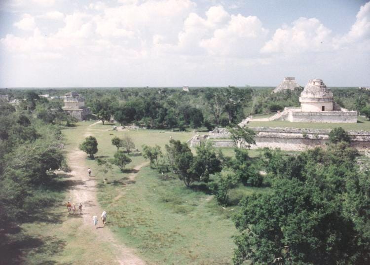
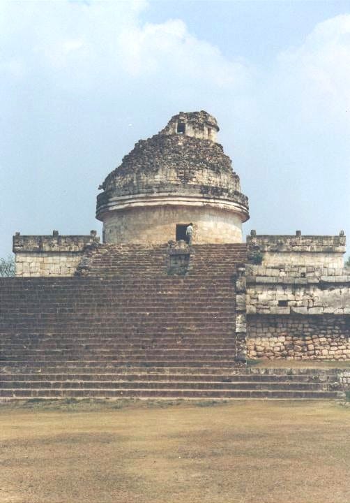
Following the trail, we came to the most prominent structure in the South Group, the Observatory or the Caracol.
The Caracol

The plaza dominated by the Caracol, the ancient Observatory of the Maya, was even more deserted. A few visitors wandered through, but we had parts of the site for ourselves.
Caracol means snail in Spanish, and by extension, “spiral”, referring to the stairway inside the structure. The only round structure in Chichen Itza, the structure was an observatory. We even know its age, from a stela on the Upper Platform, which dates it to 906 AD.
The building is one of the most studied sites for ancient Maya astronomy. The observatory is aligned to follow the path of Venus through the year. The grand staircase leading to the cylindrical structure aligns with the northern extreme of the planet, while the northeast-southwest diagonal aligns with the sunrise of the summer solstice and the sunset of the winter solstice.
These observations, among many others, were the reason the ancient Maya were such accomplished astronomers; they developed some of the most accurate astronomy without telescopes, when they could only see the celestial bodies with the naked eye. With dark skies all around, they have seen a lot more than we do today, but it’s still amazing how much they understood.
Based on their astronomical observations, they developed the most accurate calendar, or rather a combination of calendars, not only in the ancient world, but one that is still correct today. We learned from locals that they still use the ancient calendar in Maya villages today.
They were able to predict solar eclipses and movements of Venus and other celestial bodies with amazing accuracy, resulting in the Long Count calendar, a count of days.
Besides the Long Count, they had a 260-day calendar called the Tzolk’in, made up of a combination of names and numbers (20 day names and 13 numbers). This was their most important and sacred calendar, used to determine farming cycles and for religious ceremonies. Some present-day Maya communities still use this calendar for religious practices, if nothing else.
The third calendar of the ancient Maya is the Haab’, a 365-day year made up of 18 months of 19 days each, with five unlucky days at the end of the year.
The combination of the Tzolk’in and Haab’ resulted in the calendar round, which repeats approximately every 52 years.
El Caracol, standing tall with views above the surrounding canopy, was in a position to help ancient Maya people observe the skies above the vegetation without obstruction.
The Nunnery Group
Past the Caracol, on the left, we came to the Nunnery Group.
The main building, called Nunnery or Las Monjas, possibly named by the Spaniards because it reminded them of their convents, is 210 feet long, 105 feet wide, and 50 feet high. From the top, we had a great view of the Caracol observatory and the Pyramid of Kukulcan beyond.

Near the Annex to Las Monjas, the Iglesia, the Church, is one of the prettiest buildings in all of Chichen Itza, with an elegant facade hard to forget.

Though Chichen Itza is most famous for its Castillo and the North Group, I’ve always enjoyed the South Group much more. The Iglesia, with its elaborate carvings, and the round Caracol are my favorite buildings. To me, they have more of a warm feel about them, smaller in scale, but more elaborate, more artistic.
Back in 1995, we were able to climb the structures and walk into the rooms, making us feel like explorers, giving us a better understanding of what life might have been like there in ancient times, and what the early archaeologists might have found.
Though you can no longer do that, the Iglesia with its elaborate facade is worth stopping for, while leaving the bats to take up residence inside the quiet, dark rooms.
Old Chichen
On our second day of visiting the site, we walked to Old Chichen, past the South Group (after revisiting its main structures).
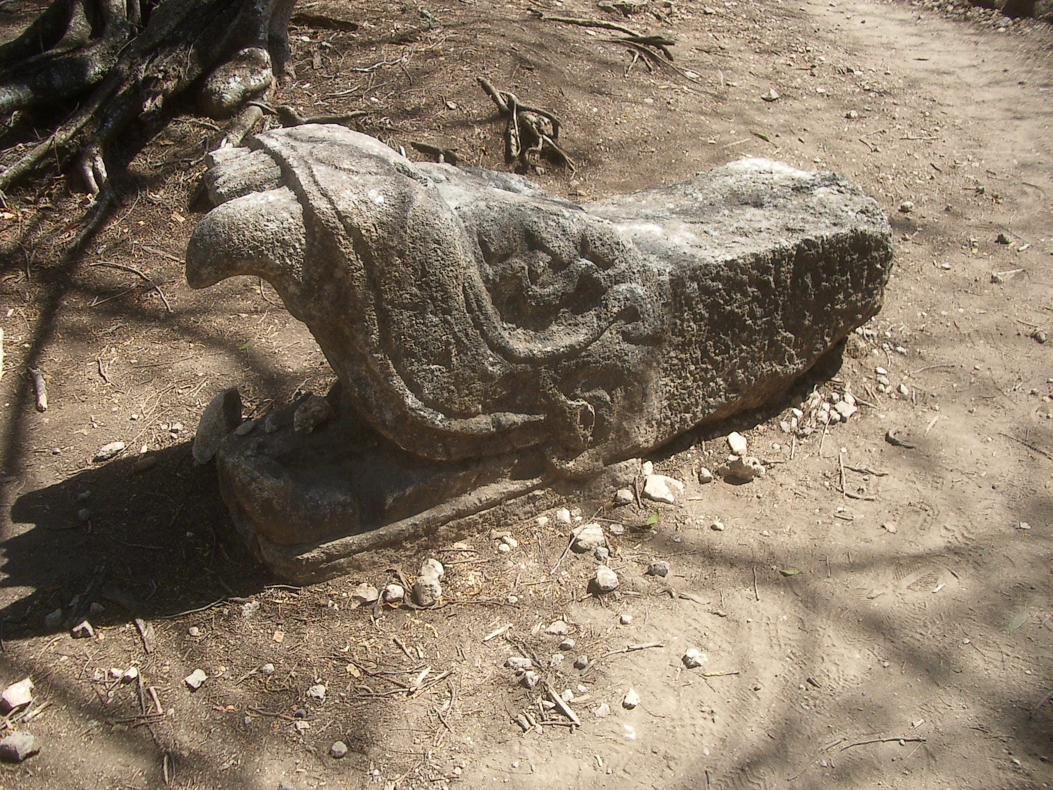
The structures in Old Chichen were scattered in the bush, most overgrown, but since no one else wandered so far in, we were alone on the trail, with an occasional iguana watching us from the bush. The only restored structure we noticed here was the Temple of the Three Lintels, a Puuc-style building. Besides that, we found pieces of structures lying on the ground, a serpent head among them.
For years - decades - after our first visit, Old Chichen was closed to visitors. Last year, when we visited, we noticed they opened it for guided tours only on certain days. We were there on the wrong days and had no time to stay longer, so we didn’t do it, but it might be worth it if you have the chance.
Another recent development in the archaeology of Chichen Itza happened while building the Maya train. During the process, many new building sites, filled with artifacts, surfaced in and around the ancient city. A brand-new museum (not yet open) showcases some of these artifacts.
Hope you enjoyed the latest installment of Travel Tales from the Land of the Maya!
Access to archaeological sites in Mexico is much different now than it was during my first visit, and I hope you like learning about what it was like before they became popular tourist destinations.
I believe visiting archaeological and historical sites helps us understand our place in the larger timeframe, put things in perspective, and offers a context of why and how we evolved to where we are today.
I also find it fun to walk through places ancient people walked, to see what they built, to understand how they lived. This understanding may help us develop empathy and understanding for different perspectives, and may offer ideas about how to go forward and make our world a better place. If we could only listen.
Enjoy visiting historical and archaeological sites, no matter where you are in the world!
Wishing you all the best! Until next time,
Emese
If you liked this post, you might enjoy others about Chichen Itza:


Or, read about other sites we visited in 1995 in Travel Tales from the Land of the Maya
You can also find more articles about Maya ruins I visited over the years:
Ancient Maya Ruins - Wanderer Writes
About Letters from a Wanderer
Letters from a Wanderer is a reader-supported publication, bringing you weekly posts about travel and places, with special focus on nature and archaeological/historical sites. Besides traveling to the places I write about, I research their history and interesting facts about them, resulting in more in-depth descriptions.
Thank you for reading!
*No part of this publication, including text and images, is created by or with the help of AI. Every word is written by me, and all photos taken by Jeff Fromm in 1995 (on an analog camera, later scanned and thus digitized).
Now that you mention the idea of falling into the cenote, I think you may be right. Great photos, loved the discussion of the southern buildings.
Emese, your photos held up remarkably well! I like the Red House one a lot. The cenote there really does have a weird vibe. Maybe bc all the sacrifice, maybe bc there seem to be a lot of trees around it (or were) and you walk a bit away from the pyramids themselves. Great to re-visit the site, through your eyes.